Processing Levels
Satellite data comes in various product levels, each product level has a different amount of processing applied to it. The exact definition of the product levels may vary slightly from satellite to satellite.
Level 0
Raw instrument data that has not been processed. This is most commonly used by the satellite imaging organization itself and unsuitable to use for applications. Level 0 products are typically not distributed are are hard to visualize.
Level 1
Geolocated so that image is mapped to coordinates on the ground and radiometry is calibrated to a reference.
Level 1C
Level 1 C is orthorectified so that north is up.
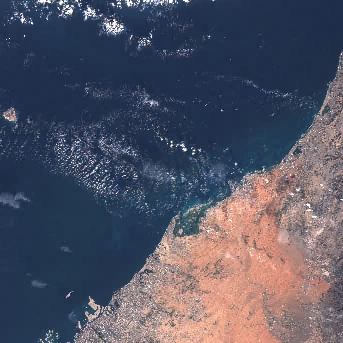 |
|---|
| Example Sentinel 2 Level 1 C Product showing Dubai. Level 1C is Top of Atmosphere(TOA) |
Level 2
Derived geophysical variables that are projected on to a map. For optical products, radiometry is in reflectance and is atomospherically corrected (Bottom of Atmosphere)
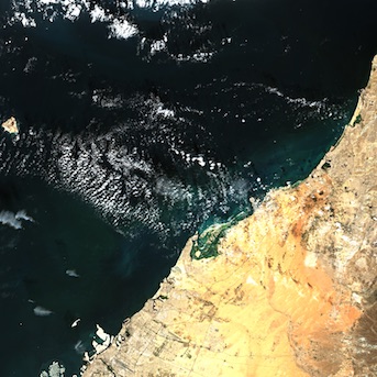 |
|---|
| Example Sentinel 2 Level 2 Product showing Dubai. Level 2 is Bottom of Atmosphere(BOA) |
Optical Radiometry Units
The terminology used for optical satellites is explained here.
Digital Numbers (DN)
Digital numbers are the raw measurements from a sensor that have not been calibrated into a scientific unit to measure the Earth's surface.
Radiance
The amount of light entering the aperture from a particular area on the ground at a particular wavelength. It has the units of Watts per steradian per squared meter $\frac{W}{sr⋅m^2}$.
Spectral Radiance
Spectral Radiance is Radiance integrated over the bandwidth of a detector channel.
Reflectance
Percentage of light reflected by the surface. Since it is a ratio, it is a unitless measure.
Atmospheric Correction
What is the different between Top of Atmosphere and Bottom of Atmosphere? See example images in Level 1C and Level 2 section.
Top of Atmosphere (TOA)
Effects of atmosphere have not been corrected in the signal. Compared to Bottom of Atmosphere products, Top of Atmosphere products are bluish in colour.
Bottom of Atmosphere (BOA)
Signal has been corrected for the atmosphere and measures the Earth's surface. When available a Bottom of Atmosphere product should be used for analyzing the Earth's surface. BOA is sometimes also called Top of Canopy(TOC).
BRDF Correction
Nadir BRDF Adjusted Reflectance (NBAR)
NBAR products have corrected for the BRDF effects.